
The Climate in China - Use this Guide, Know your Destination's Climate
- Rhys
- Sep 1, 2020
- 8 min read
Updated: Oct 22, 2020
When travelling, the two main things you need to know about the weather are 1) the temperature; and 2) the rainfall. Other factors such as length of days, wind, and cloud conditions may be helpful too.
Once your destinations in China are planned, it’s smart to know the general climate and weather habits of the regions you will go to so that you know what to expect and what you’ll need to bring.
China is so large that it does not have a single climate but many, including everything from sub-tropical to frigid temperate. The vast and varied territory of Mainland China can be divided into basic climate zones according to these weather similarities and differences, as shown in this climate map of China. Learn all about these regions, the seasons, and how they relate to your trip below.
[contents]
Intro: What's this guide i'm reading?
[contents in the rest of this guide]
- What are the two main regions in China?
- What climate zones does China have?
- Where are China’s temperate climate zones?
- Where are China’s subtropical/tropical climate zones?
- Where are China’s plateau climate zone?
- What are the temperatures by month in major Chinese cities?
- Understand rainfall for your travel.

General Climate Regions in Mainland China: the North and the South
- What are the two main regions in China?
The Yangtze River (the red line on the map) is the natural borderline [RE1] that divides the heavily populated eastern area of China into two main areas of land: the north and the south. There are important geological and cultural differences between these two regions.
- What’s the weather like in the south of China?
Generally, the weather in Southern China is humid and wet. Summers in the south commonly bring monsoon rains. Winters are relatively dry and mild. Rough average temperatures range from 9°C (48°F) in Winter to 30°C (86°F) in Summer. With the exception of the occasional typhoon, extreme weather conditions and temperatures in southern China are rare.
- What’s the weather like in the north of China?
The weather in the Central and Northern China is more variable than in the south, changing at throughout the year. Summers temperatures in moderate to hot and dry. Approximate average temperatures range from -10°C (14°F) in Winter to around 25°C (77°F) in Summer. However, Winters can reach down to -20°C (-4°F) and below in some areas.
Three big climate types to guide your travel in China
- What climate zones does China have?
China is big. When you visit, chances are you will do some moving from place to place, region to region. Read this section to understand what weather you should expect when travelling across larger regions of China.
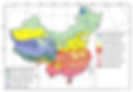
Even within the north and south, the general climate can vary significantly from region to region. Because of this, simply understanding dividing China into North and South is not enough – we need more detail. Therefore, we bring you the ‘Climate map of China’ (the map below).


The Climate map of China shows us the 11 specific climate zones of the mainland, which can be divided up into 3 big weather zones. These are:

Read below to understand these climate zones and types and find the climate best suited to you and your travel plans, or which climates you are most likely to encounter on your travels.
- Where are China’s temperate climate zones?
The Temperate Climate Zones

The map shows China’s temperate climate area, outlined in red. This area includes three specific temperate-climate zones, called the cold (blue), mid-(pale blue-green) and warm(yellow) temperate zones.
The word “temperate” refers to mild or moderate temperatures.
Places located in the temperate zones experience the biggest changes in temperature and other climate conditions from season to season.
This means sunny Summers, dramatic colorful Autumns, snow-capped Winters and flowery springs.
Your experience travelling in these regions is likely to differ greatly depending on what time of year you decide to visit.

The Cold Temperate Zone.
China’s cold temperate zone is situated in the far north of the mainland. The zone locates within Inner Mongolia’s far north-eastern tip which shares a border with Russia.
The climate of the city of Hulun Buir reflects the climate of this temperature zone. The yearly average temperature for Hulun Buir is -0.6°C (30.92°F). The yearly rainfall for Hulun Buir is around 356mm.
Winters here are long and harsh.

The Mid-temperate Zone
The Mid-temperate zone is a band that essentially spans the length of China’s northern border.
The following four cities can be used to represent the climate in this zone:
West: Urumqi (Xinjiang)
Mid-west: Dunhuang (Gansu)
Mid-east: Hohhot (Inner Mongolia)
East: Harbin (Heilongjiang)

The Warm Temperate Zone
The warm temperate zone has patches in western, south-central, and eastern China.
The following six cities can be used to represent the climate in this zone:
West: Kashgar (Xinjiang)
East: Xi’an(Anhui); Beijing (Shanxi); Qingdao (Shandong)
South Central: Lhasa(Tibet); Zhaotong(Yunnan);
- Where are China’s subtropical/tropical climate zones?
The Subtropical/Tropical Climate Zones

The map shows China’s subtropical/tropical climate area, outlined in red. This area includes three specific zones: the north, mid- and south subtropical/tropical zones. Additionally, small parts of the southern coast of China belong to what is known as the edge tropical zone climate zone.
Subtropical locations generally mean long hot summers and mild winters. China’s subtropical zones are the humid type, meaning lots of rain in summer and less in winter.
To avoid the rainy season, travel this region in March, April or May if you prefer cooler temperatures, or August and September if you like the heat.
The north subtropical climate zone
The north subtropical climate zone runs inland on the northern edge of the Yangtze River, from Shanghai and Hangzhou near the coast to Xi’an and Lanzhou. There are also small pockets in China’s central south that share this climate, in the provinces of Guizhou and Yunnan.
Cities that can give you a gist of this climate include:
Center south: Dali (Yunnan), Anshun (Guizhou)
Central/Inland: Xi’an (Shaan’xi), Lauzhou (Gansu)
East: Shanghai, Hangzhou (Zhejiang)

The mid-subtropical climate zone
The mid-subtropical climate zone roughly occupies the space between the Yangtze River’s southern edge and the upper borders of the coastal provinces of Guangdong and Guangxi. This band stretches from the cities of Taizhou and Wenzhou on the eastern coast up until the mountains of the inland province of Sichuan.
Understand this climate zone by checking the climate information for the following cities:
West: Chengdu (Sichuan)
Central: Guiin (Guangxi)
East: Taizhou (Zhejiang)

The south subtropical climate zone
The south subtropical climate zone runs along the coast, from the Fujian province cities of Fuzhou and Xiamen along to the border of Vietnam and across the center of Yunnan province.
Check climate info for these cities to understand the characteristics of this zone:
East: Xiamen (Fujian)
Central: Guangzhou (Guangdong)
West: Kunming (Yunnan)

The edge tropical climate zone
The edge tropical climate zone is localised to small patches in the provinces of Tibet, Yunnan, Guangxi, Hainan and the southern tip of Guangdong.
Check climate information for the following cities to learn about the climate in this zone:
Tibet: Cona
Yunnan: Xishuangbanna
Guangdong and Hainan: Sanya
- Where are China’s plateau climate zone?
The Plateau Climate Zone

The map shows four types of plateau climate zone: plateau temperate, plateau subtemperate, cold plateau sub zone, and cold plateau zone.
China’s Qinghai-Tibetan plateau is an area of elevated land which sits an average of 4000 meters above sea level. Because of their height, these areas have strong solar radiation during the day. This also means dramatic variations in temperature at night, after the sun sets. Winters are dry, windy and cold. Summers are mild and cool.

The plateau temperate zone
The plateau temperate zone is a relatively small climate zone located in the south western portion of the Tibetan province, stretching from the intersection point of the borders of Sichuan and Yunnan across to the area the Gyaring Co and Nam Co lakes.
See weather report information for the following cities to learn about the climate in this zone:
East: Bangdaxiang
Central west: Lhasa

The plateau subtemperate zone
The plateau cold subtemperate zone is a large climate zone that spans covers most of the southern half of Tibet, the west-north-western half of Sichuan and a small portion of the east of Qinghai province.
See weather report information for the following cities to learn about the climate in this zone:
Qinghai: Hainan
Sichuan: Aba
Western south Tibet: Ngari

The cold plateau sub zone
The cold plateau zone covers an area along the northern border of Qinghai, as well as the southern half of the province of Qinghai and a band the stretches across central Tibet from the border of south Qinghai in the east to the border of Jammu and Kashmir in the west.
Cities and regions that can give you a gist of this climate include:
North Qinghai: Qilan County
South Qinghai: Yanshiping Town
Southeast Qinghai: Yushu
East central Tibet: Nagqu
West central Tibet: Rutog

The cold plateau zone
The cold plateau zone essentially runs along the border between the provinces of Tibet and Xinjiang, covering land in western Qinghai in the east and stretching up along the western border of Xinjiang – the border shared with Pakistan, Tajikistan and Kyrgyzstan.
Check these cities to understand the general climate for this zone:
Oops! Turns out there aren’t any cities here. We’ll get back to this after some research.
- Temperatures by month in major Chinese cities
Below is a table of the average temperatures (°C) in major cities in China:

What you need to know about Rainfall.
Besides the temperature of your destination, it’s also a good idea to know how likely it is to rain. Understand the rainfall patterns of your destinations to be fully prepared and ensure you get the trip you planned for.
Below we:
1) use your real-world experience to explain how rainfall is measured
2) divide the globe up based on rainfall so that you can know how the rest of the world compares to the places you’ve lived in and know
3) show you China’s rainfall by region, so that you can use your experience to understand what to expect at your destinations in China
- What is “precipitation”?
What does it actually mean to say that a place got however many mm of rain in a month/year?
“Precipitation” refers to any that is in or has fallen from the sky and includes five types: rain, drizzle, snow, sleet and freezing rain. The most common is rain, and this is why we often call precipitation “rainfall”.
Rainfall is measured in millimeters(mm) or inches(in) of rain per square meter over some amount of time. That is, the amount of rain, per square meter, per hour, month, year… and so on.
50mm/hour If a place got 50mm(1.97in) of rain in the last hour, this means that in last hour 50mm of water fell onto each square meter patch of land.
In other words, if you put a 1m2 flat container on each meter of land in this place, then waited for one month for the rain to fill them and then measured how deep the water is, it would be exactly 50mm deep in each container. Each 1-meter patch of land received 50mm of water.

Once we understand this, we can ask the questions: how much rainfall do wet/normal/dry places get?
By the way: 50mm/hr is A LOT of rain. Here’s the classification for light-heavy rain for reference.
drizzle, also called light rain = < 2.5 mm (0.098 in) per hour
normal rain = 2.5 mm (0.098 in) - 7.6 mm (0.30 in) or 10 mm (0.39 in) per hour
heavy rain = > 7.6 mm (0.30 in) per hour
pouring rain, also called violent rain = > 50 mm (2.0 in) per hour
Amount of rain by region: the world
- How many mm of annual rainfall is considered high/normal/low?
The map below is a rainfall map of the world based on the yearly average of rainfall for each region. region. Use the key table in the bottom left-hand corner of the map to understand the amount of rainfall for each region.
The earth’s average yearly rainfall is 990mm (38.96in). Places with more rain than this can be considered relatively wet; those with less rain are relatively dry. Compare your home’s rainfall level with you destination in China.

Amount of rain by region: Mainland China
- What are the rainiest and driest parts of China?
China’s average yearly national rainfall is around 630mm (24.8in), lower than the annual yearly average.
The map below shows the amounts of yearly rainfall by region.
Use this map to understand which regions of China are the rainiest and driest when planning your travel.

That's all for now folks. Stay tuned for updates.